Photoâreport on a kayak trip around Lake Baikal
From River Bolshoi Chivyrkui to the southern borders of the Barguzine Nature Reserve

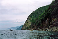
24th July, 31st day out, 908 km. Sheer cliffs to the north of the River Bolshoi Chivyrkui. A ridge of sheer cliffs stretch for 15 kilometres, now and then broken by river valleys.

24th July, 31st day out, 912 km. Cliffs to the north of Kedrovaya River keeps gloomy.

24th July, 31st day out, 915 km. Rockâelephant. Svyatoy Nos Peninsula in the distance.

24th July, 31st day out, 918 km. Valley of Malaya Cheremshana River.

24th July, 31st day out, 919 km. At the River Malaya Cheremshana. The Svyatoi Nos Peninsular can be seen on the horizon.

25th July, 32nd day out, 920 km. Rockâelephant. There are two such in these parts.

25th July, 32nd day out, 935 km. On Cape Razbor.
Barguzine Nature Reserve

25th July, 32nd day out, 938 km. In the southern part of Sosnovka Bay. Everywhere bear prints on the shore.

25th July, 32nd day out, 941 km. River Shumilikha.

26th July, 33rd day out, 958 km. River Tarkulik.

26th July, 33rd day out, 958 km. Footâbridge over the river Tarkulik.

27th July, 34th day out, 972 km. The village of Davsha in the bay of the same name. Forest fires in the Barguzine Nature Reserve are spotted with the help of this aircraft.

27th July, 34th day out, 973 km. The Nemnyanda Cape. Halfway along the Baikal`s shore.

27th July, 34th day out, 993 km. Barguzine Nature Reserve.

28th July, 35th day out, 1033 km. The Irinda River.

28th July, 35th day out, 1034 km. In Irinda Bay.

28th July, 35th day out, 1043 km. Cape Maloe Pongonye haloed by the fog.

29th July, 36th day out, 1055 km. In the Bolshoy Amnundakan Bay.
Next: Part 5. The eastern coast from River Shegnanda to Cape Nemnyanka


